
- BY Crystal
- POSTED IN Company, Front Page, News
- WITH 0 COMMENTS
- PERMALINK
- STANDARD POST TYPE
Mr. Victor (Vic) French reports:
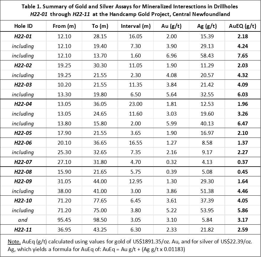
BAY ROBERTS, NEWFOUNDLAND / February 9th, 2023 / PUDDLE POND RESOURCES INC. (the “Company” or “Puddle Pond”) is pleased to report thatit has completed an additional three (3) diamond drillholes on the Handcamp Gold Project, which is located close to the Town of South Brook in central Newfoundland. Year-round access to the Project, which is located alongside the Trans-Canada Highway is excellent. The latest drillholes (H22-12, -13, and -14) were completed in November/December 2022 and are an extension of the highly successful inaugural drill program that took place in the summer of 2022 (see Summary in Table 1).
Assay highlights from the three latest drillholes (all with dips of -50°) are:
H22-12
1.80 g/t Au & 23.87 g/t Ag over 1.40 metres (4.7 feet) starting at a down-hole depth of 28.65 metres; and 0.53 g/t Au & 3.86 g/t Ag over 4.65 metres (15 feet) starting at 39.70 metres.
H22-13
1.29 g/t Au & 8.35 g/t Ag over 2.50 metres (8 feet) starting at 71.20 metres within a broader interval of 0.61 g/t Au & 6.09 g/t Ag over 13.40 metres (44 feet) starting at 60.30 metres.
H22-14
3.03 g/t Au & 59.74 g/t Ag over 4.10 metres (13.5 feet) starting at a depth of 27.60 metres.
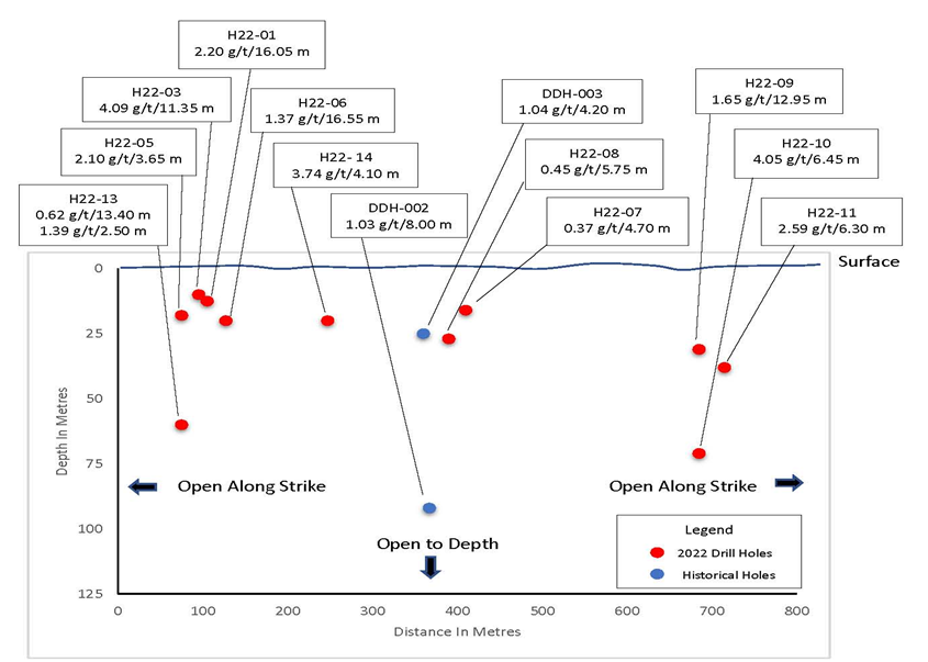
These latest drill results further consolidate the overall tenor and scale of the near-surface zone of gold mineralization (i.e., vertical depths of less than 100 metres; Figure 1) discovered by Puddle Pond’s prospecting team in 2021.
The >9,500-hectare Handcamp Gold Project, which is 100%-owned with no underlying royalties, covers much of the northern part of the Buchans-Roberts Arm belt of submarine volcanic rocks that is well known as the host of several past-producing mining operations including the world famous Buchans Mine and the nearby Gullbridge Deposit. In addition, the property also envelops a long (>20 km), continuous section of the “Red Indian Line”, a major, regional lithotectonic boundary and transcrustal fault system (Figure 2). Throughout the 1970s, 80s, and 90s, the project area was the focus of volcanogenic massive sulphide (VMS) exploration, but the discovery of high-grade gold mineralization in 2004-05 by local prospectors (138.1 g/t Au in float; 27.0 g/t Au in outcrop; Lannon, 2005) shifted the focus.
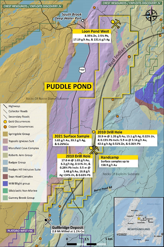
Puddle Pond’s summer (2022) exploration program determined that on an outcrop scale, the gold mineralization at Handcamp is hosted in a combination of highly deformed quartz veins that exhibit evidence of both ductile and brittle deformation, and intensely foliated and quartz-sericite-pyrite altered volcanic rocks that display evidence of shearing and isoclinal folding. Also, lithostructural analysis performed by consultants Geokincern Ltd. of Auckland (New Zealand), indicates the presence of a district-scale shear zone (>15 km in length) comprised of an anastomosing system of faults that exhibit both strike-slip and dip-slip components of movement.
Victor French, P.Geo., a Qualified Person as defined by NI 43-101 and President & COO for Puddle Pond, is responsible for the technical information contained in this News Release.
On Behalf of the Board of Directors
“Victor A. French”
1-709-786-7978
contactus@puddlepondresources.com
About Puddle Pond Resources Inc.: Puddle Pond Resources is a Newfoundland-based mineral exploration company (headquartered in Bay Roberts, Conception Bay) focused on the identification and development of undervalued mineral assets in the Province of Newfoundland & Labrador, one of the Fraser Institute’s top-10 mining jurisdictions in the world. The Company’s present foci are Orogenic Gold, Epithermal Gold-Silver, and Volcanogenic Massive Sulphide deposits. Presently, the Company holds the rights to more than 90,000 hectares (>900 km2) of mineral claims on the Island of Newfoundland, distributed amongst 19 individual properties that are situated in either the “Central Newfoundland Gold Belt”, the “Baie Verte Mining District”, or the “Avalonian Epithermal Belt”.
(Data Sources: Lannon, G., 2005; 1st Year Assessment Report, Handcamp Property, Central Newfoundland. Government of Newfoundland & Labrador Department of Natural Resources Assessment Report 012H/08/1788; 2nd Year Assessment Report, Handcamp Property, Central Newfoundland, Government of Newfoundland & Labrador Department of Natural Resources Assessment Report 012H/08/1780).