- BY Crystal
- POSTED IN Company, Front Page, News
- WITH 0 COMMENTS
- PERMALINK
- STANDARD POST TYPE
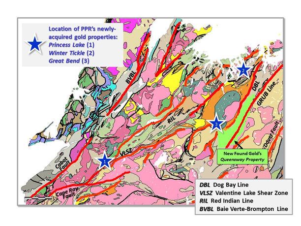
Victor (Vic) French, President & COO of Puddle Pond Resources (the “Company”) is pleased to announce the acquisition of the “Winter Tickle” and “Princess Lake” gold properties. These acquisitions mean that the Company now holds three highly prospective gold occurrences in the Central Newfoundland Gold Belt, viz. “Great Bend”, “Winter Tickle”, and “Princess Lake” (see Map). Each of the new properties is 100% owned by Puddle Pond Resources and is subject only to a small royalty. Details of the new gold properties are as follows:
1. Princess Lake Property1
· Located within the southwestern area of the Dunnage Zone bordering properties held by TRU Precious Metals Corp., Altius Resources Inc., and Matador Mining Ltd.
· The 1400-hectare property is underlain by granitic rocks of the Lloyds River Intrusive Suite which are unconformably overlain by sandstone and conglomerate of the Devonian Windsor Point Group.
· Hosts the “Second Exploits” gold occurrence, where the mineralized quartz veins are exposed along a 500-metre section of altered and sheared granite.
· The gold-mineralized veins, which carry up to 5.5 g/t Au form small, anastomosing networks, have chloritic alteration envelopes and contain sphalerite, galena, pyrite, and specularite. Visible gold has only been observed in quartz-vein float that returned an assay value of 25 g/t Au.
2. Winter Tickle Property2
· Located within the northern area of the Dunnage Zone bordering properties held by Shawn Ryan. This 400-hectare property is underlain by siliciclastic rocks of the Exploits Group (a prolific host for gold occurrences in the Central Newfoundland Gold Belt) into which are emplaced numerous sheets of the Thwart Island Gabbro.
· Hosts the “Danny Boy” gold occurrence, where the gold mineralization is associated with sheared gabbros that have been strongly altered to quartz-carbonate assemblages. Gold occurs in banded to brecciated, quartz-carbonate veins up to 0.75 metres wide that are associated with local brittle-ductile shear zones likely linked to a larger fault structure that trends NNE-SSW and crosses the entire property.
· The gold-mineralized veins typically host 1-3% (locally up to 15%) arsenopyrite and have returned values of up to 9.8 g/t Au from trenching.
3. Great Bend Property3,4,5
· Composed of three small, closely spaced claim groups (650 hectares), situated in the central portion of the Dunnage Zone, underlain by rocks of the Great Bend ultramafic complex and siliciclastic rocks of the Davidsville Group or by mélange comprised of a chaotic, tectonic mixture of sedimentary, ultramafic, and gabbroic rocks.
· The property hosts several significant gold occurrences including: (a) “Chiouk Brook” where mineralized boulders have returned values of up to 18.6 g/t Au, outcrop samples values of up to 22.2 g/t Au, and drill-core values of 14.55 g/t Au over 0.25 metre; (b) “Lizard Pond South” where trenching has exposed quartz breccia-veins with 12.50 g/t Au over 0.4 metres and 6.58 g/t Au over 1.2 metres; and (c) “Breccia Pond” where channel samples in the vicinity of a 7,500 ppb gold-in-soil anomaly returned values of 3.24 g/t Au and 1.72 g/t Au.
· The “Great Bend Property” shares a common boundary with New Found Gold’s “Queensway Property”, which is located immediately to the east (see Map).
In addition to the latest acquisitions described above, the Company is also in the advanced stage of negotiations with other local prospectors for two further gold properties located in the “Valentine Lake Structural Corridor” of the Central Newfoundland Gold Belt, one of which also has excellent potential for volcanogenic massive sulphide (VMS) mineralization.
References:
1) Evans, D.T.W. “Epigenetic Gold Occurrences of the Eastern Dunnage Zone, Newfoundland” (1994), 315 pages [NFLD/2728]
2) Newfoundland & Labrador Geological Survey Assessment File 2E/06/1434 (2005), 73 pages.
3) Newfoundland & Labrador Geological Survey Assessment File 2D/11/0171 (1987), 49 pages.
4) Newfoundland & Labrador Geological Survey Assessment File 2D/11/0217 (1989), 240 pages.
5) Newfoundland & Labrador Geological Survey Assessment File 2D/11/0675 (2006), 29 pages.